Today, glaciers cover approximately 10% of the world's surface, and are mainly found in polar areas such as Antarctica, the Arctic and Greenland. In the geologically recent past - about 20,000 years ago - glaciers covered about 32% of the land and 30% of the oceans. By 10,000 years ago, the ice was retreating. Today's glaciers are the remains of those much larger ice fields.
Scientists working on the thickest glaciers and ice fields have drilled ice cores that show there have been 8 ice ages during the last 750,000 years, separated by warmer times which are known as interglacial periods. Today we are in an interglacial period and despite apparent global warming, geologists know that we should be nearing the end of the current warm period. If past cycles carry on, we should be entering the next ice age in a few thousand years, and the glaciers will start to advance again.
An ice age exists when the average world temperatures drop and stay that way for a long period of time. There are several reasons why this may happen, but the chief three seem to be atmospheric composition, small wobbles in the Earth's orbit around the Sun, known as Milankovitch cycles, and the shifting locations of the continents.
The composition of the atmosphere, particularly the amount of CO2 and methane, changes the ability of the atmosphere to retain or lose heat. Low levels of methane and CO2 allow atmospheric temperatures to drop whilst high levels of these greenhouse gasses allow heat to be retained.
As we drift into an orbit that gives us a little less exposure to the Sun's warmth we cool down, and an ice age begins. Temperatures stay cool until the Earth's orbit changes again and temperatures warm up. At that point an interglacial period begins.
The positions of the continents are important because when they are close to the poles they create a larger surface area to collect snow, thus increasing the chances of ice forming. When they are close to the equator there is less land on which snow can accumulate.
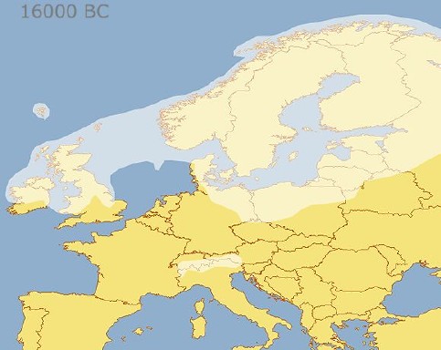
During the last ice age, glaciers advanced across most of Canada, Alaska, Great Britain, Ireland and the former Soviet Union. As more water became locked up in the ice sea levels dropped by 400 feet and land became exposed. This enabled people to walk to BritainFebruary 23, 2006rope was just one example of the way in which country and continent shapes change as sea level rise or drop. If we enter a new ice age we can expect sea levels to drop again, and eventually Britain may yet again be linked to France by land.
Map showing the extent of ice sheets across Europe about 18,000 years ago. The original version of this map can be found at Norwaymyway
|
|
 d d |
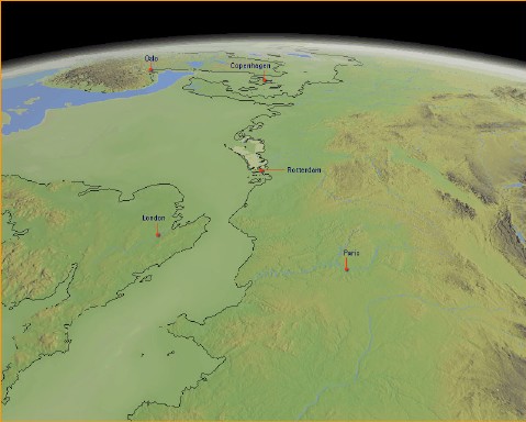
At the height of the last ice age sea levels dropped by 400 feet, exposing land that is now covered by water. As you can see, it was once possible to walk from France to Britain, then head north to Denmark. The existence of these additional land areas helped archaeologists to explain migration and settlement patterns in ancient Europe. |
![]()