| Introduction | Burundi |
|
Background:
|
Burundi's first democratically elected president was assassinated in October 1993 after only one hundred days in office. Since then, some 200,000 Burundians have perished in widespread, often intense ethnic violence between Hutu and Tutsi factions. Hundreds of thousands have been internally displaced or have become refugees in neighboring countries. Burundi troops, seeking to secure their borders, briefly intervened in the conflict in the Democratic Republic of the Congo in 1998. A new transitional government, inaugurated on 1 November 2001, signed a power-sharing agreement with the largest rebel faction in December 2003 and set in place a provisional constitution in October 2004. Implementation of the agreement has been problematic, however, as one remaining rebel group refuses to sign on and elections have been repeatedly delayed, clouding prospects for a sustainable peace. |
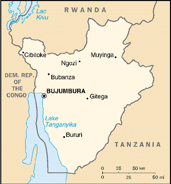
| Geography | Burundi |
|
Location:
|
Central Africa, east of Democratic Republic of the Congo |
|
Geographic coordinates:
|
3 30 S, 30 00 E |
|
Map references:
|
Africa |
|
Area:
|
total: 27,830 sq km
land: 25,650 sq km water: 2,180 sq km |
|
Area - comparative:
|
slightly smaller than Maryland |
|
Land boundaries:
|
total: 974 km
border countries: Democratic Republic of the Congo 233 km, Rwanda 290 km, Tanzania 451 km |
|
Coastline:
|
0 km (landlocked) |
|
Maritime claims:
|
none (landlocked) |
|
Climate:
|
equatorial; high plateau with considerable altitude variation (772 m to 2,670 m above sea level); average annual temperature varies with altitude from 23 to 17 degrees centigrade but is generally moderate as the average altitude is about 1,700 m; average annual rainfall is about 150 cm; wet seasons from February to May and September to November, and dry seasons from June to August and December to January |
|
Terrain:
|
hilly and mountainous, dropping to a plateau in east, some plains |
|
Elevation extremes:
|
lowest point: Lake Tanganyika 772 m
highest point: Heha 2,670 m |
|
Natural resources:
|
nickel, uranium, rare earth oxides, peat, cobalt, copper, platinum, vanadium, arable land, hydropower, niobium, tantalum, gold, tin, tungsten, kaolin, limestone |
|
Land use:
|
arable land: 35.05%
permanent crops: 14.02% other: 50.93% (2001) |
|
Irrigated land:
|
740 sq km (1998 est.) |
|
Natural hazards:
|
flooding, landslides, drought |
|
Environment - current issues:
|
soil erosion as a result of overgrazing and the expansion of agriculture into marginal lands; deforestation (little forested land remains because of uncontrolled cutting of trees for fuel); habitat loss threatens wildlife populations |
|
Environment - international agreements:
|
party to: Biodiversity, Climate Change, Climate Change-Kyoto Protocol, Desertification, Endangered Species, Hazardous Wastes, Ozone Layer Protection
signed, but not ratified: Law of the Sea |
|
Geography - note:
|
landlocked; straddles crest of the Nile-Congo watershed; the Kagera, which drains into Lake Victoria, is the most remote headstream of the White Nile |
| People | Burundi |
|
Population:
|
6,370,609
note: estimates for this country explicitly take into account the effects of excess mortality due to AIDS; this can result in lower life expectancy, higher infant mortality and death rates, lower population and growth rates, and changes in the distribution of population by age and sex than would otherwise be expected (July 2005 est.) |
|
Age structure:
|
0-14 years: 46% (male 1,479,941/female 1,450,808)
15-64 years: 51.3% (male 1,617,864/female 1,653,331) 65 years and over: 2.6% (male 66,199/female 102,466) (2005 est.) |
|
Median age:
|
total: 16.6 years
male: 16.27 years female: 16.95 years (2005 est.) |
|
Population growth rate:
|
2.22% (2005 est.) |
|
Birth rate:
|
39.66 births/1,000 population (2005 est.) |
|
Death rate:
|
17.43 deaths/1,000 population (2005 est.) |
|
Net migration rate:
|
0 migrant(s)/1,000 population (2005 est.) |
|
Sex ratio:
|
at birth: 1.03 male(s)/female
under 15 years: 1.02 male(s)/female 15-64 years: 0.98 male(s)/female 65 years and over: 0.65 male(s)/female total population: 0.99 male(s)/female (2005 est.) |
|
Infant mortality rate:
|
total: 69.29 deaths/1,000 live births
male: 75.87 deaths/1,000 live births female: 62.5 deaths/1,000 live births (2005 est.) |
|
Life expectancy at birth:
|
total population: 50.29 years
male: 49.61 years female: 50.99 years (2005 est.) |
|
Total fertility rate:
|
5.81 children born/woman (2005 est.) |
|
HIV/AIDS - adult prevalence rate:
|
6% (2003 est.) |
|
HIV/AIDS - people living with HIV/AIDS:
|
250,000 (2003 est.) |
|
HIV/AIDS - deaths:
|
25,000 (2003 est.) |
|
Major infectious diseases:
|
degree of risk: very high
food or waterborne diseases: bacterial diarrhea, hepatitis A, and typhoid fever vectorborne disease: malaria (2004) |
|
Nationality:
|
noun: Burundian(s)
adjective: Burundian |
|
Ethnic groups:
|
Hutu (Bantu) 85%, Tutsi (Hamitic) 14%, Twa (Pygmy) 1%, Europeans 3,000, South Asians 2,000 |
|
Religions:
|
Christian 67% (Roman Catholic 62%, Protestant 5%), indigenous beliefs 23%, Muslim 10% |
|
Languages:
|
Kirundi (official), French (official), Swahili (along Lake Tanganyika and in the Bujumbura area) |
|
Literacy:
|
definition: age 15 and over can read and write
total population: 51.6% male: 58.5% female: 45.2% (2003 est.) |
| Government | Burundi |
|
Country name:
|
conventional long form: Republic of Burundi
conventional short form: Burundi local long form: Republika y'u Burundi local short form: Burundi former: Urundi |
|
Government type:
|
republic |
|
Capital:
|
Bujumbura |
|
Administrative divisions:
|
16 provinces; Bubanza, Bujumbura, Bururi, Cankuzo, Cibitoke, Gitega, Karuzi, Kayanza, Kirundo, Makamba, Muramvya, Muyinga, Mwaro, Ngozi, Rutana, Ruyigi |
|
Independence:
|
1 July 1962 (from UN trusteeship under Belgian administration) |
|
National holiday:
|
Independence Day, 1 July (1962) |
|
Constitution:
|
13 March 1992; provided for establishment of a plural political system; supplanted on 20 October 2004 by a provisional constitution approved by the parliament which extended the transition; a 28 February 2005 popular referendum ratified the new constitution which set ethnic quotas for government positions, and tentatively scheduled general elections for April 2005 |
|
Legal system:
|
based on German and Belgian civil codes and customary law; has not accepted compulsory ICJ jurisdiction |
|
Suffrage:
|
NA years of age; universal adult |
|
Executive branch:
|
chief of state: President Domitien NDAYIZEYE (since 30 April 2003); note - NDAYIZEYE, a Hutu, was sworn in as president for the second half of the three-year transitional government inaugurated on 1 November 2001; Vice President Frederic NGENZEBUHORO (since 11 November 2004)
head of government: President Domitien NDAYIZEYE (since 30 April 2003); note - NDAYIZEYE, a Hutu, was sworn in as president for the second half of the three-year transitional government inaugurated on 1 November 2001; Vice President Frederic NGENZEBUHORO (since 11 November 2004) cabinet: Council of Ministers appointed by president elections: NA; current president assumed power on 30 April 2003 as part of the transitional government established by the 2000 Arusha Accord; note - next presidential election is scheduled for 22 April 2005 |
|
Legislative branch:
|
bicameral, consists of a National Assembly or Assemblee Nationale (expanded from 121 to approximately 140 seats under the transitional government inaugurated 1 November 2001; members are elected by popular vote to serve five-year terms) and a Senate (54 seats; term length is undefined, the current senators will likely serve out the three-year transition period)
elections: last held 29 June 1993 (next was scheduled to be held in 1998, but was suspended by presidential decree in 1996; elections are currently planned to be held by April 2005) election results: percent of vote by party - FRODEBU 71.04%, UPRONA 21.4%, other 7.56%; seats by party - FRODEBU 65, UPRONA 16, civilians 27, other parties 13 |
|
Judicial branch:
|
Supreme Court or Cour Supreme; Constitutional Court; Courts of Appeal (there are three in separate locations); Tribunals of First Instance (17 at the province level and 123 small local tribunals) |
|
Political parties and leaders:
|
the three national, mainstream, governing parties are: Unity for National Progress or UPRONA [Jean-Baptiste MANWANGARI, secretary general]; Burundi Democratic Front or FRODEBU [Jean MINANI, president]; National Council for the Defense of Democracy, Front for the Defense of Democracy of CNDD-FDD [Pierre NKURUNZIZA, president]
note: a multiparty system was introduced after 1998, included are: National Resistance Movement for the Rehabilitation of the Citizen or MRC-Rurenzangemero [Epitace BANYAGANAKANDI]; Party for National Redress or PARENA [Jean-Baptiste BAGAZA] |
|
Political pressure groups and leaders:
|
loosely organized Hutu and Tutsi militias, often affiliated with Hutu and Tutsi extremist parties or subordinate to government security forces |
|
International organization participation:
|
ACCT, ACP, AfDB, AU, CEPGL, FAO, G-77, IBRD, ICAO, ICCt, ICFTU, ICRM, IDA, IFAD, IFC, IFRCS, ILO, IMF, Interpol, IOC, IOM (observer), ISO (subscriber), ITU, MIGA, NAM, OPCW, UN, UNCTAD, UNESCO, UNIDO, UPU, WCO, WHO, WIPO, WMO, WToO, WTO |
|
Diplomatic representation in the US:
|
chief of mission: Ambassador Antoine NTAMOBWA
chancery: Suite 212, 2233 Wisconsin Avenue NW, Washington, DC 20007 telephone: [1] (202) 342-2574 FAX: [1] (202) 342-2578 |
|
Diplomatic representation from the US:
|
chief of mission: Ambassador James Howard YELLIN
embassy: Avenue des Etats-Unis, Bujumbura mailing address: B. P. 1720, Bujumbura telephone: [257] 223454 FAX: [257] 222926 |
|
Flag description:
|
divided by a white diagonal cross into red panels (top and bottom) and green panels (hoist side and outer side) with a white disk superimposed at the center bearing three red six-pointed stars outlined in green arranged in a triangular design (one star above, two stars below) |
| Economy | Burundi |
|
Economy - overview:
|
Burundi is a landlocked, resource-poor country with an underdeveloped manufacturing sector. The economy is predominantly agricultural with roughly 90% of the population dependent on subsistence agriculture. Economic growth depends on coffee and tea exports, which account for 90% of foreign exchange earnings. The ability to pay for imports, therefore, rests primarily on weather conditions and international coffee and tea prices. The Tutsi minority, 14% of the population, dominates the government and the coffee trade at the expense of the Hutu majority, 85% of the population. Since October 1993 an ethnic-based war has resulted in more than 200,000 deaths, forced 450,000 refugees into Tanzania, and displaced 140,000 others internally. Doubts about the prospects for sustainable peace continue to impede development. Only one in two children go to school, and approximately one in ten adults has HIV/AIDS. Food, medicine, and electricity remain in short supply. |
|
GDP (purchasing power parity):
|
$4.001 billion (2004 est.) |
|
GDP - real growth rate:
|
3% (2004 est.) |
|
GDP - per capita:
|
purchasing power parity - $600 (2004 est.) |
|
GDP - composition by sector:
|
agriculture: 48.1%
industry: 19% services: 32.9% (2004 est.) |
|
Labor force:
|
2.99 million (2002) |
|
Labor force - by occupation:
|
agriculture 93.6%, industry 2.3%, services 4.1% (2002 est.) |
|
Unemployment rate:
|
NA |
|
Population below poverty line:
|
68% (2002 est.) |
|
Household income or consumption by percentage share:
|
lowest 10%: 1.8%
highest 10%: 32.9% (1998) |
|
Distribution of family income - Gini index:
|
42.5 (1998) |
|
Inflation rate (consumer prices):
|
8.5% (2004 est.) |
|
Investment (gross fixed):
|
10.7% of GDP (2004 est.) |
|
Budget:
|
revenues: $152.5 million
expenditures: $187.7 million, including capital expenditures of NA (2004 est.) |
|
Agriculture - products:
|
coffee, cotton, tea, corn, sorghum, sweet potatoes, bananas, manioc (tapioca); beef, milk, hides |
|
Industries:
|
light consumer goods such as blankets, shoes, soap; assembly of imported components; public works construction; food processing |
|
Industrial production growth rate:
|
18% (2001) |
|
Electricity - production:
|
132 million kWh (2002) |
|
Electricity - production by source:
|
fossil fuel: 0.6%
hydro: 99.4% nuclear: 0% other: 0% (2001) |
|
Electricity - consumption:
|
137.8 million kWh (2002) |
|
Electricity - exports:
|
0 kWh (2002) |
|
Electricity - imports:
|
15 million kWh; note - supplied by the Democratic Republic of the Congo (2002) |
|
Oil - production:
|
0 bbl/day (2001 est.) |
|
Oil - consumption:
|
2,750 bbl/day (2001 est.) |
|
Oil - exports:
|
NA |
|
Oil - imports:
|
NA |
|
Current account balance:
|
$-59.5 million (2004 est.) |
|
Exports:
|
$31.84 million f.o.b. (2004 est.) |
|
Exports - commodities:
|
coffee, tea, sugar, cotton, hides |
|
Exports - partners:
|
Germany 19.6%, Belgium 8.2%, Pakistan 6.7%, US 5.6%, Rwanda 5.6%, Thailand 5.4% (2004) |
|
Imports:
|
$138.2 million f.o.b. (2004 est.) |
|
Imports - commodities:
|
capital goods, petroleum products, foodstuffs |
|
Imports - partners:
|
Kenya 13.7%, Tanzania 11.2%, US 8.9%, Belgium 8.5%, France 8.4%, Italy 6%, Uganda 5.6%, Japan 4.6%, Germany 4.5% (2004) |
|
Reserves of foreign exchange and gold:
|
$76.89 million (2004 est.) |
|
Debt - external:
|
$1.133 billion (2002) |
|
Economic aid - recipient:
|
$92.7 million (2000) |
|
Currency (code):
|
Burundi franc (BIF) |
|
Currency code:
|
BIF |
|
Exchange rates:
|
Burundi francs per US dollar - 1,100.91 (2004), 1,082.62 (2003), 930.75 (2002), 830.35 (2001), 720.67 (2000) |
|
Fiscal year:
|
calendar year |
| Communications | Burundi |
|
Telephones - main lines in use:
|
23,900 (2003) |
|
Telephones - mobile cellular:
|
64,000 (2003) |
|
Telephone system:
|
general assessment: primitive system
domestic: sparse system of open-wire, radiotelephone communications, and low-capacity microwave radio relay international: country code - 257; satellite earth station - 1 Intelsat (Indian Ocean) |
|
Radio broadcast stations:
|
AM 0, FM 4, shortwave 1 (2001) |
|
Radios:
|
440,000 (2001) |
|
Television broadcast stations:
|
1 (2001) |
|
Televisions:
|
25,000 (1997) |
|
Internet country code:
|
.bi |
|
Internet hosts:
|
22 (2003) |
|
Internet Service Providers (ISPs):
|
1 (2000) |
|
Internet users:
|
14,000 (2003) |
| Transportation | Burundi |
|
Highways:
|
total: 14,480 km
paved: 1,028 km unpaved: 13,452 km (1999 est.) |
|
Waterways:
|
mainly on Lake Tanganyika (2004) |
|
Ports and harbors:
|
Bujumbura |
|
Airports:
|
8 (2004 est.) |
|
Airports - with paved runways:
|
total: 1
over 3,047 m: 1 (2004 est.) |
|
Airports - with unpaved runways:
|
total: 7
914 to 1,523 m: 4 under 914 m: 3 (2004 est.) |
| Military | Burundi |
|
Military branches:
|
National Defense Force (Forces de Defense Nationales, FDN): Army (includes Naval Detachment and Air Wing), National Gendarmerie (2005) |
|
Military service age and obligation:
|
16 years of age for compulsory and voluntary military service (2001) |
|
Manpower available for military service:
|
males age 16-49: 1,379,793 (2005 est.) |
|
Manpower fit for military service:
|
males age 16-49: 693,956 (2005 est.) |
|
Manpower reaching military service age annually:
|
males: 84,597 (2005 est.) |
|
Military expenditures - dollar figure:
|
$38.7 million (2004) |
|
Military expenditures - percent of GDP:
|
6% (2004) |
| Transnational Issues | Burundi |
|
Disputes - international:
|
Tutsi, Hutu, other conflicting ethnic groups, associated political rebels, armed gangs, and various government forces continue fighting in the Great Lakes region, transcending the boundaries of Burundi, Democratic Republic of the Congo, Rwanda, and Uganda in an effort to gain control over populated and natural resource areas; government heads pledge to end conflict, but localized violence continues despite the presence of about 6,000 peacekeepers from the UN Operation in Burundi (ONUB) since 2004; although some 150,000 Burundian refugees have been repatriated, as of February 2005, Burundian refugees still reside in camps in western Tanzania as well as the Democratic Republic of the Congo |
|
Refugees and internally displaced persons:
|
refugees (country of origin): 60,288 (Democratic Republic of the Congo)
IDPs: 140,000 (armed conflict between government and rebels; most IDPs in northern and western Burundi) (2004) |
Sources: The CIA World Fact Book and other public domain Internet sites