| Introduction | Sierra Leone |
|
Background:
|
The 1991 to 2002 civil war between the government and the Revolutionary United Front (RUF) resulted in tens of thousands of deaths and the displacement of more than 2 million people (about one-third of the population), many of whom are now refugees in neighboring countries. With the support of the UN peacekeeping force and contributions from the World Bank and international community, demobilization and disarmament of the RUF and Civil Defense Forces (CDF) combatants has been completed. National elections were held in May 2002 and the government continues to slowly reestablish its authority. However, the gradual withdrawal of most UN Mission in Sierra Leone (UNAMSIL) peacekeepers in 2004 and early 2005, deteriorating political and economic conditions in Guinea, and the tenuous security situation in neighboring Liberia may present challenges to the continuation of Sierra Leone's stability. |
| Geography | Sierra Leone |
|
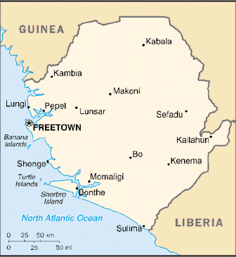
Location:
|
Western Africa, bordering the North Atlantic Ocean, between Guinea and Liberia |
|
Geographic coordinates:
|
8 30 N, 11 30 W |
|
Map references:
|
Africa |
|
Area:
|
total: 71,740 sq km
land: 71,620 sq km water: 120 sq km |
|
Area - comparative:
|
slightly smaller than South Carolina |
|
Land boundaries:
|
total: 958 km
border countries: Guinea 652 km, Liberia 306 km |
|
Coastline:
|
402 km |
|
Maritime claims:
|
territorial sea: 12 nm
contiguous zone: 24 nm exclusive economic zone: 200 nm continental shelf: 200 nm |
|
Climate:
|
tropical; hot, humid; summer rainy season (May to December); winter dry season (December to April) |
|
Terrain:
|
coastal belt of mangrove swamps, wooded hill country, upland plateau, mountains in east |
|
Elevation extremes:
|
lowest point: Atlantic Ocean 0 m
highest point: Loma Mansa (Bintimani) 1,948 m |
|
Natural resources:
|
diamonds, titanium ore, bauxite, iron ore, gold, chromite |
|
Land use:
|
arable land: 6.98%
permanent crops: 0.89% other: 92.13% (2001) |
|
Irrigated land:
|
290 sq km (1998 est.) |
|
Natural hazards:
|
dry, sand-laden harmattan winds blow from the Sahara (December to February); sandstorms, dust storms |
|
Environment - current issues:
|
rapid population growth pressuring the environment; overharvesting of timber, expansion of cattle grazing, and slash-and-burn agriculture have resulted in deforestation and soil exhaustion; civil war depleting natural resources; overfishing |
|
Environment - international agreements:
|
party to: Biodiversity, Climate Change, Desertification, Endangered Species, Law of the Sea, Marine Life Conservation, Ozone Layer Protection, Ship Pollution, Wetlands
signed, but not ratified: Environmental Modification |
|
Geography - note:
|
rainfall along the coast can reach 495 cm (195 inches) a year, making it one of the wettest places along coastal, western Africa |
| People | Sierra Leone |
|
Population:
|
6,017,643 (July 2005 est.) |
|
Age structure:
|
0-14 years: 44.7% (male 1,318,508/female 1,371,164)
15-64 years: 52% (male 1,494,068/female 1,637,276) 65 years and over: 3.3% (male 93,047/female 103,580) (2005 est.) |
|
Median age:
|
total: 17.53 years
male: 17.2 years female: 17.84 years (2005 est.) |
|
Population growth rate:
|
2.22% (2005 est.) |
|
Birth rate:
|
42.84 births/1,000 population (2005 est.) |
|
Death rate:
|
20.61 deaths/1,000 population (2005 est.) |
|
Net migration rate:
|
0 migrant(s)/1,000 population
note: refugees currently in surrounding countries are slowly returning (2005 est.) |
|
Sex ratio:
|
at birth: 1.03 male(s)/female
under 15 years: 0.96 male(s)/female 15-64 years: 0.91 male(s)/female 65 years and over: 0.9 male(s)/female total population: 0.93 male(s)/female (2005 est.) |
|
Infant mortality rate:
|
total: 143.64 deaths/1,000 live births
male: 161.06 deaths/1,000 live births female: 125.69 deaths/1,000 live births (2005 est.) |
|
Life expectancy at birth:
|
total population: 39.87 years
male: 37.74 years female: 42.06 years (2005 est.) |
|
Total fertility rate:
|
5.72 children born/woman (2005 est.) |
|
HIV/AIDS - adult prevalence rate:
|
7% (2001 est.) |
|
HIV/AIDS - people living with HIV/AIDS:
|
170,000 (2001 est.) |
|
HIV/AIDS - deaths:
|
11,000 (2001 est.) |
|
Major infectious diseases:
|
degree of risk: very high
food or waterborne diseases: bacterial and protozoal diarrhea, hepatitis A, and typhoid fever vectorborne diseases: malaria and yellow fever are high risks in some locations water contact disease: schistosomiasis aerosolized dust or soil contact disease: Lassa fever (2004) |
|
Nationality:
|
noun: Sierra Leonean(s)
adjective: Sierra Leonean |
|
Ethnic groups:
|
20 native African tribes 90% (Temne 30%, Mende 30%, other 30%), Creole (Krio) 10% (descendants of freed Jamaican slaves who were settled in the Freetown area in the late-18th century), refugees from Liberia's recent civil war, small numbers of Europeans, Lebanese, Pakistanis, and Indians |
|
Religions:
|
Muslim 60%, indigenous beliefs 30%, Christian 10% |
|
Languages:
|
English (official, regular use limited to literate minority), Mende (principal vernacular in the south), Temne (principal vernacular in the north), Krio (English-based Creole, spoken by the descendants of freed Jamaican slaves who were settled in the Freetown area, a lingua franca and a first language for 10% of the population but understood by 95%) |
|
Literacy:
|
definition: age 15 and over can read and write English, Mende, Temne, or Arabic
total population: 29.6% male: 39.8% female: 20.5% (2000 est.) |
| Government | Sierra Leone |
|
Country name:
|
conventional long form: Republic of Sierra Leone
conventional short form: Sierra Leone |
|
Government type:
|
constitutional democracy |
|
Capital:
|
Freetown |
|
Administrative divisions:
|
3 provinces and 1 area*; Eastern, Northern, Southern, Western* |
|
Independence:
|
27 April 1961 (from UK) |
|
National holiday:
|
Independence Day, 27 April (1961) |
|
Constitution:
|
1 October 1991; subsequently amended several times |
|
Legal system:
|
based on English law and customary laws indigenous to local tribes; has not accepted compulsory ICJ jurisdiction |
|
Suffrage:
|
18 years of age; universal |
|
Executive branch:
|
chief of state: President Ahmad Tejan KABBAH (since 29 March 1996, reinstated 10 March 1998); note - the president is both the chief of state and head of government
head of government: President Ahmad Tejan KABBAH (since 29 March 1996, reinstated 10 March 1998); note - the president is both the chief of state and head of government cabinet: Ministers of State appointed by the president with the approval of the House of Representatives; the cabinet is responsible to the president elections: president elected by popular vote for a five-year term; election last held 14 May 2002 (next to be held May 2007); note - president's tenure of office is limited to two five-year terms election results: Ahmad Tejan KABBAH reelected president; percent of vote - Ahmad Tejan KABBAH (SLPP) 70.6%, Ernest KOROMA (APC) 22.4% |
|
Legislative branch:
|
unicameral Parliament (124 seats - 112 elected by popular vote, 12 filled by paramount chiefs elected in separate elections; members serve five-year terms)
elections: last held 14 May 2002 (next to be held May 2007) election results: percent of vote by party - SLPP 70.06%, APC 22.35%, PLP 3%, others 4.59%; seats by party - SLPP 83, APC 27, PLP 2 |
|
Judicial branch:
|
Supreme Court; Appeals Court; High Court |
|
Political parties and leaders:
|
All People's Congress or APC [Ben KANU]; Peace and Liberation Party or PLP [Darlington MORRISON, interim chairman]; Sierra Leone People's Party or SLPP [Sama BANYA]; numerous others |
|
Political pressure groups and leaders:
|
trade unions and student unions |
|
International organization participation:
|
ACP, AfDB, AU, C, ECOWAS, FAO, G-77, IAEA, IBRD, ICAO, ICCt, ICFTU, ICRM, IDA, IDB, IFAD, IFC, IFRCS, ILO, IMF, IMO, Interpol, IOC, IOM, ITU, MIGA, NAM, OIC, OPCW, UN, UNCTAD, UNESCO, UNIDO, UPU, WCL, WCO, WFTU, WHO, WIPO, WMO, WToO, WTO |
|
Diplomatic representation in the US:
|
chief of mission: Ambassador Ibrahim M. KAMARA
chancery: 1701 19th Street NW, Washington, DC 20009 telephone: [1] (202) 939-9261 through 9263 FAX: [1] (202) 483-1793 |
|
Diplomatic representation from the US:
|
chief of mission: Ambassador Thomas N. HULL
embassy: Corner of Walpole and Siaka Stevens Streets, Freetown mailing address: use embassy street address telephone: [232] (22) 226481 through 226485 FAX: [232] (22) 225471 |
|
Flag description:
|
three equal horizontal bands of light green (top), white, and light blue |
| Economy | Sierra Leone |
|
Economy - overview:
|
Sierra Leone is an extremely poor African nation with tremendous inequality in income distribution. While it possesses substantial mineral, agricultural, and fishery resources, its economic and social infrastructure is not well developed, and serious social disorders continue to hamper economic development. About two-thirds of the working-age population engages in subsistence agriculture. Manufacturing consists mainly of the processing of raw materials and of light manufacturing for the domestic market. Plans to reopen bauxite and rutile mines shut down during an 11 year civil war have not been implemented due to lack of foreign investment. Alluvial diamond mining remains the major source of hard currency earnings. The fate of the economy depends upon the maintenance of domestic peace and the continued receipt of substantial aid from abroad, which is essential to offset the severe trade imbalance and supplement government revenues. International financial institutions contributed over $600 million in development aid and budgetary support in 2003. |
|
GDP (purchasing power parity):
|
$3.335 billion (2004 est.) |
|
GDP - real growth rate:
|
6% (2004 est.) |
|
GDP - per capita:
|
purchasing power parity - $600 (2004 est.) |
|
GDP - composition by sector:
|
agriculture: 49%
industry: 30% services: 21% (2001 est.) |
|
Labor force:
|
1.369 million (1981 est.) |
|
Labor force - by occupation:
|
agriculture NA, industry NA, services NA |
|
Unemployment rate:
|
NA |
|
Population below poverty line:
|
68% (1989 est.) |
|
Household income or consumption by percentage share:
|
lowest 10%: 0.5%
highest 10%: 43.6% (1989) |
|
Distribution of family income - Gini index:
|
62.9 (1989) |
|
Inflation rate (consumer prices):
|
1% (2002 est.) |
|
Budget:
|
revenues: $96 million
expenditures: $351 million, including capital expenditures of NA (2000 est.) |
|
Agriculture - products:
|
rice, coffee, cocoa, palm kernels, palm oil, peanuts; poultry, cattle, sheep, pigs; fish |
|
Industries:
|
diamonds mining; small-scale manufacturing (beverages, textiles, cigarettes, footwear); petroleum refining, small commercial ship repair |
|
Industrial production growth rate:
|
NA |
|
Electricity - production:
|
255.3 million kWh (2002) |
|
Electricity - production by source:
|
fossil fuel: 100%
hydro: 0% nuclear: 0% other: 0% (2001) |
|
Electricity - consumption:
|
237.4 million kWh (2002) |
|
Electricity - exports:
|
0 kWh (2002) |
|
Electricity - imports:
|
0 kWh (2002) |
|
Oil - production:
|
0 bbl/day (2001 est.) |
|
Oil - consumption:
|
6,500 bbl/day (2001 est.) |
|
Oil - exports:
|
NA |
|
Oil - imports:
|
NA |
|
Exports:
|
$49 million f.o.b. (2002 est.) |
|
Exports - commodities:
|
diamonds, rutile, cocoa, coffee, fish (1999) |
|
Exports - partners:
|
Belgium 61.6%, Germany 11.8%, US 5.4% (2004) |
|
Imports:
|
$264 million f.o.b. (2002 est.) |
|
Imports - commodities:
|
foodstuffs, machinery and equipment, fuels and lubricants, chemicals (1995) |
|
Imports - partners:
|
Germany 14%, Cote d'Ivoire 10.7%, UK 9.1%, US 8.4%, China 5.6%, Netherlands 5%, South Africa 4.1% (2004) |
|
Debt - external:
|
$1.5 billion (2002 est.) |
|
Economic aid - recipient:
|
$103 million (2001 est.) |
|
Currency (code):
|
leone (SLL) |
|
Currency code:
|
SLL |
|
Exchange rates:
|
leones per US dollar - 2,701.3 (2004), 2,347.9 (2003), 2,099 (2002), 1,986.2 (2001), 2,092.1 (2000) |
|
Fiscal year:
|
calendar year |
| Communications | Sierra Leone |
|
Telephones - main lines in use:
|
24,000 (2002) |
|
Telephones - mobile cellular:
|
67,000 (2002) |
|
Telephone system:
|
general assessment: marginal telephone and telegraph service
domestic: the national microwave radio relay trunk system connects Freetown to Bo and Kenema international: country code - 232; satellite earth station - 1 Intelsat (Atlantic Ocean) |
|
Radio broadcast stations:
|
AM 1, FM 9, shortwave 1 (1999) |
|
Radios:
|
1.12 million (1997) |
|
Television broadcast stations:
|
2 (1999) |
|
Televisions:
|
53,000 (1997) |
|
Internet country code:
|
.sl |
|
Internet hosts:
|
277 (2004) |
|
Internet Service Providers (ISPs):
|
1 (2001) |
|
Internet users:
|
8,000 (2002) |
| Transportation | Sierra Leone |
|
Highways:
|
total: 11,300 km
paved: 904 km unpaved: 10,396 km (2002) |
|
Waterways:
|
800 km (2003) |
|
Ports and harbors:
|
Freetown, Pepel, Sherbro Islands |
|
Merchant marine:
|
total: 2 ships (1,000 GRT or over) 7,435 GRT/8,750 DWT
by type: petroleum tanker 2 (2005) |
|
Airports:
|
10 (2004 est.) |
|
Airports - with paved runways:
|
total: 1
over 3,047 m: 1 (2004 est.) |
|
Airports - with unpaved runways:
|
total: 9
914 to 1,523 m: 7 under 914 m: 2 (2004 est.) |
|
Heliports:
|
2 (2004 est.) |
| Military | Sierra Leone |
|
Military branches:
|
Republic of Sierra Leone Armed Forces (RSLAF): Army (includes Air Wing, Maritime Wing) |
|
Military service age and obligation:
|
18 years of age (est.); no conscription (2001) |
|
Manpower available for military service:
|
males age 18-49: 1,110,077 (2005 est.) |
|
Manpower fit for military service:
|
males age 18-49: 552,785 (2005 est.) |
|
Military expenditures - dollar figure:
|
$13.2 million (2004) |
|
Military expenditures - percent of GDP:
|
1.7% (2004) |
| Transnational Issues | Sierra Leone |
|
Disputes - international:
|
domestic fighting among disparate rebel groups, warlords, and youth gangs in Cote d'Ivoire, Guinea, Liberia, and Sierra Leone perpetuate insurgencies, street violence, looting, arms trafficking, ethnic conflicts, and refugees in border areas; UN Mission in Sierra Leone (UNAMSIL) has maintained over 4,000 peacekeepers in Sierra Leone since 1999; Sierra Leone pressures Guinea to remove its forces from the town of Yenga occupied since 1998 |
|
Refugees and internally displaced persons:
|
refugees (country of origin): 67,000 (Liberia) (2004) |
Sources: The CIA World Fact Book and other public domain Internet sites